
Walk 5: The Pillbox Safari
It’s June 1940, the ‘miracle’ at Dunkirk has just seen over 300,000 troops evacuated from the Northern shores of France. Now on the back foot, Churchill has stated “The Battle of France is over and the Battle of Britain is about to begin”.
With a Nazi invasion imminent, Commander in Chief, General Edmund Ironside (a former pupil of Tonbridge school pupil) has ordered the mass construction of anti-tank lines in a last ditch effort to protect Britain against the threat of Hitlers advancing army.
Pack up your old kit bag and say your goodbyes as we embark on an inspection of the pill boxes.

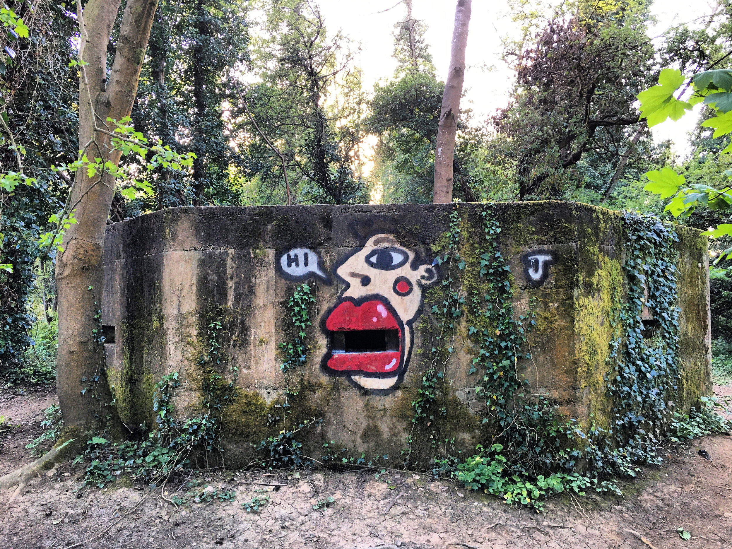
Tonbridge School pillbox (Pillbox 1 of 7 on this walk)
The pill boxes you will see on this walk are just a small link in a historic chain of defence, but will hopefully give you an insight into these remnants of World War 2 and the defensive line that “Fort Tonbridge” once sat upon.
Begin your walk at the North end of the High Street where the road forks off towards Hildenborough. The first of the safari box is tucked away on the right, in the grounds of Tonbridge school. There’s a little information plaque marking its location. This box was uncovered during the construction of the schools new science block in 2018. It was one of two, (the second - since destroyed - was located across the road on the corner of Portman park), built to defend the road blocks that would have spanned the junction here. At the time the high street was the main route to London, meaning that the Nazis would have had to negotiate their way through past this point if they were to advance onto the capital.
Continue South down the High Street, cross over Lansdowne Road and then turn right into Bank Street, following the road round as it becomes The Slade. To your left you will see the Castle gate house. It’s twin towers were used during the war by the Observer Corps, who relocated here from Quarry Hill in order to get a better vantage point of approaching enemy aircraft.

Tonbridge Castle, its gatehouse was used by the Observer Corps as a lookout point during WW2
Walk downhill and then trace the road round past Slade school. The schools town centre location and proximity to the Luftwaffe bombers flight path to London meant that it was considered at a high risk of air raids. In response, a network of underground shelters was built under the school playground with a capacity for up to 500 people. You can read more about these and see some images here.
To your right there will be a path signposted for Penshurst. Follow the stream as it snakes between the sports fields. During the war time these pitches and the nearby park would have been littered with obstacles such as old machinery and barrels of earth, designed to prevent enemy gliders from landing on these flat open spaces.
Keep going until you reach the railway line. The railway played a huge role in the aftermath of Dunkirk, when over 181,000 soldiers were freighted out of Dover and Ramsgate. Hungry and exhausted from their wait on the beach and the battle in France, these soldiers would have been relieved to have seen Tonbridge, one of several designated feeding stations set up to revitalise the troops passing through. You can read more about this here.
Walk under the very low railway bridge and then take the path to the right, crossing the small concrete foot bridge. Hidden in the trees to your right will be the second pill box on this trail.
This box is the most accessible of the trail. The door has not been sealed up and its not succumbed to the surrounding vegetation, meaning you are free to walk around it should you wish to explore. Explore with care as you can never be sure who or what has been in before you!

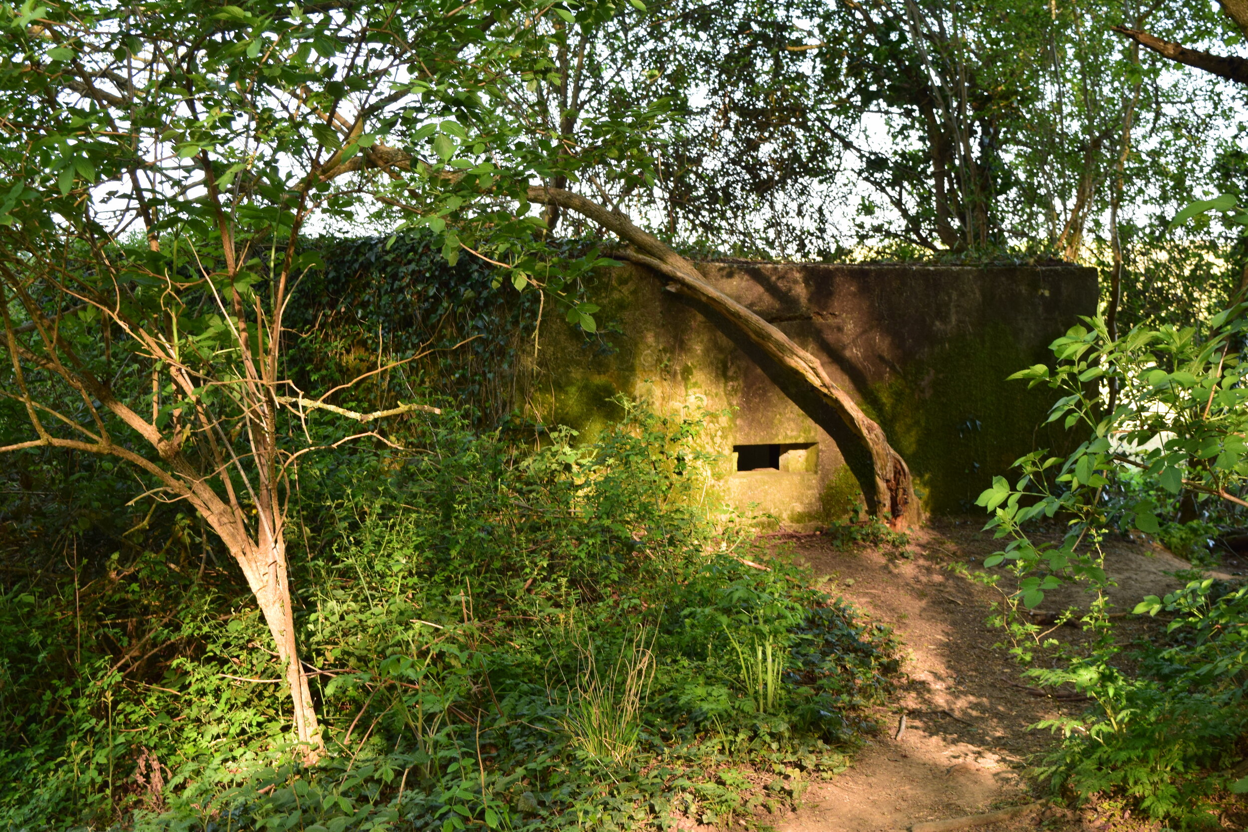
Pillbox number 2
Unlike the box at Tonbridge school, which was of a rare adhoc design, this is a standard FW324 type box - concrete bunker in the shape of an irregular hexagon. Each wall has an embrasure to which a light machine gun or rifle could be fired from. The windows were narrower on the inside than the outside, giving the maximum amount of shielding whilst providing the greatest possible line of sight- much like a traditional castle loop hole. At the entrance of the box there is a Y shaped wall, designed to support the roof and limit the risk of bullets ricocheting around inside. The concrete walls and roof were designed to be bullet proof and in some instances reinforced further to be made shell proof.
Keep going straight until you meet a junction in the path. Turn right and cross over the little bridge. This takes you onto a long tarmac path running alongside an old gravel pit, now a fishing lake.

Inside a FW3/24 pillbox (in this case Lisa & Steve’s love shack)
Eventually the path narrows and gradually climbs up hill. Walk past the sheep field and you will come out at the Powdermills, a small hamlet between Hildenborough and Leigh. The area took its name from the gunpowder factory that was established here in the 1800’s. The powder produced here was mainly for sporting weapons, but expanded to military munitions in the lead up to the first world war. Gunpowder production eventually ceased in the 1930’s, not before a series of huge blasts though! You can read more about this areas explosive history here.
Turn right down Powdermills, walking downhill towards the oast house. The housing estate on your left is the old site of the old gunpowder factory, later a pharmaceutical research centre for Glaxosmithkline (GSK).
Turn left at the bottom of the road and follow the lane round to the Plough. This is a beautiful country pub with a huge family friendly garden for the warmer months and a roaring log fire in winter. It’s best to call ahead if you plan to stop in for a drink/lunch as it’s a popular wedding venue.

The Plough, near The Powdermills
Once you are fed and watered, turn right out of the pub and walk up the road for 450 metres (passing Burton Avenue), until you see a footpath on the left running beside a white cottage.
Continue through the big metal gate and down the muddy track. At the end you will reach a large field. Turn to your right and follow the perimeter until you see a small foot bridge cutting through the hedge.
The third pill box on this trail is just slightly further along and can be seen where the hedge juts out into the field. It guards the stream and would have provided cover in the event of enemies parachuting into this field. The pill box is so overgrown that its difficult to make out its shape, but this adds to its authenticity. During wartime the boxes would have often been camouflaged to give them an added element of surprise.

Pill Box number 3, near Leigh flood barrier
Make your way back to the little bridge and walk diagonally across the field. Ahead of you will be a fortification of a very different kind - the towns flood barrier. Before its construction Tonbridge would flood regularly, and with devastating effect. The barrier has reduced the risk significantly but was unable to stop the floods of Christmas 2013, which hit the town and nearby Hildenborough very hard.
Once you reach the corner of the field you can go through the gate to view the barrier before doubling back and taking the path back along the edge of the field keeping the river to your right.

Leigh flood barrier
Walk past the bridge and then carry on through the trees along the river. On the opposite bank you will see Hayesden country park.
Pill box number 4 is buried deep in the hedge beside you. It’s so well hidden that I walked past this at least three times before spotting it. This is located adjacent to the fork in the river, around 20 metres before the sloping bench. The brambles surrounding this are as sharp as any barbed wire, so its best viewed from the path.

Pillbox 4
Like the others you have seen this is a FW324 type, one of 7 designs issued by the directorate of Fortifications and Works (FW3), a section of the war office. The basic blueprint meant that the boxes could be built quickly by soldiers and local labour forces. By the end of August 1940 there were estimated to have been 18,000 boxes built across the UK. You can read more about the different designs here.
Keep walking until you spot a fifth pill box hiding in the undergrowth to your left. This one is also surrounded by brambles and bushes, but if wearing long clothes you should be able to squeeze through the gap in the hedge for a better look.

Pillbox 5
By using a standard size for the doors and windows, weapons could be deployed to different boxes along the line with confidence that they would be compatible with these miniature concrete forts.
The boxes would have most likely been manned by the the Home Guard, an army of 1.5 million volunteers that were either too old or young to serve in the regular army, or were restricted by their profession, for example Policemen or farmers. You can view a picture of The Tonbridge Home guard here, courtesy of the Tonbridge Historical Society.
Continue along the river and the 6th pill box will be to your left, just after the river gauge. This one is easier to spot but unlike the others is submerged a bit deep into into the ground, giving it the feel of a bunker. The entrance has been left unsealed but the box is now waterlogged so do not attempt to enter.

Pillbox 6, under attack
The stretch of river that you have walked today forms part of the GHQ’s Eastern stop line. A continuous run of pill boxes, tank traps and barbed-wire that stretched from Newhaven, Sussex to Hoo in North Kent. Across the water from Hoo, the line resumed in Essex and ran as far as Edinburgh, Scotland. Further downriver at Penshurst the line would met the Western line, running all the way to Bristol. These lines were designed to slow the suspected Nazi invasions progress to London, buying time in the event of an invasion.
Walk past Lucifer’s Bridge and you will see the 7th and final Pill Box of this walk on your left. This one is tucked in between the footpath and the cycle path that runs on the opposite side of the hedge. Its smothered in ivy, but its door is still accessible should you wish to explore inside.
It’s difficult to imagine being stationed in one of these concrete chambers, staring into the whites of the eyes of an enemy soldier, but thankfully this is a situation that never occurred. By mid-September the RAF had taken the upper hand in The Battle of Britain, prompting Hitler to postpone his invasion indefinitely as he began to focus his efforts on planning for his invasion of Russia, seemingly a softer target.

Pillbox 7
Cross over the two bridges and turn right, where you will then rejoin the path you took earlier. Walk past pillbox 2 which you saw earlier on this safari and go back under the railway line.
Continue straight and then take the path to the right, past the dead tree. Cross over the bridge, pausing to take in the view. This is one of the highest points in the park and offers a panoramic view of South Tonbridge. Look around and you can spot The Parish Church, the old gasworks, Quarry Hill, St Stephens Church and Barden park. During the war a German doodlebug crashed on Tinkers Island, very close to this part of the park.

Tonbridge park (Racecourse sports ground) at sunset
Turn left and walk along the river until you reach the park gates. Take another left and then cross the bridge, walking past the swimming pool. Go over the bridge near the entrance of the pool and then turn right, walking round Castle Walk.
The Castle sat directly on the GHQ line and was further fortified during the war to strengthen the towns defences. Tonbridge’s strategic location meant that it was classified as a designated fortress town during the war. Besides the pillbox at Tonbridge school, two more pill boxes and machine gun emplacements were built into the walls beside you, along with a huge gun pit that was dug into the lawn near the memorial. These would have been built to defend Big Bridge, a crucial tactical point in the event of an invasion.
Continue through the gates and onto the High Street where this walk ends. Treat yourself to a coffee and a slice of cake at 60mm coffee or if you fancy something stronger there are plenty of options to choose from in the town.

Big Bridge, Tonbridge High Street
Afterword and credits
Growing up in Tonbridge I took the many pillboxes around the town for granted. They had always been there and like many residents I had never truly questioned these. After posting some pictures of a walk to the flood barrier a friend suggested we take “a pill box safari” coining the name for this walk (Thank you V.S.) and prompting hours of research into these little concrete forts.
Upon reading up on the pillboxes I found a brilliant book about Tonbridge and its defences during WW2. Its written by Paul Tritton and is called “Tonbridge Fortress”. The book is free to download and is a fascinating and informative read. I have referenced this extensively for the sections of this walk that feature the town centre.
You may also be interested in this blog post about the pill boxes of Leigh, posted by Sue Featherstone on the Leigh Historical site. This includes information on the pill boxes West of the Leigh flood barrier.
Lastly, this post by Jessica Havard is also a fun and informative read if you are interested in a more personal account of Tonbridge during the second world war.